
Garmin eTrex SE
4.2Editor score
Water-resistant IPX7 rating
Multi-GNSS satellite support
Up to 168 hours battery
Navigating the open water requires reliable tools to ensure safety and efficiency. A handheld GPS for boating offers portable navigation that keeps you oriented during any marine excursion.
We compared ten top-rated marine GPS units based on durability, chart quality, battery life, and satellite support. This list covers options from budget-friendly to premium models.
Each pick shows key features and real-world performance data to help you choose wisely. Note that prices and availability change frequently, so check current listings before buying.
4.2Editor score

4.0Editor score
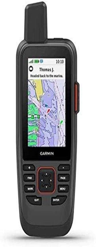
4.2Editor score
As an Amazon Associate we earn from qualifying purchases.
This side-by-side comparison evaluates all ten products across critical specs like display size, map preload, satellite support, battery life, and water resistance to help you decide quickly.



The Garmin GPSMAP 79sc stands out as a top marine handheld GPS with rugged durability and preloaded coastal charts. It holds a 4.0 rating from users who appreciate its reliability on the water.
We may earn a commission when you buy through this link, at no additional cost to you.
Its standout qualities include a floating design that prevents loss overboard and a high-resolution display visible in bright sunlight. The preloaded BlueChart g3 coastal charts provide essential navigation data right out of the box.
The device supports multiple satellite constellations like GPS, GLONASS, and Galileo for reliable tracking worldwide. It also tracks up to 10,000 waypoints and 250 routes for complex journey planning.
Boaters who need a robust and accurate handheld GPS for boating should consider this model. It balances advanced features with practical design elements that keep you safe and oriented on the open water.
The preloaded BlueChart g3 coastal charts combine the best of Garmin and Navionics data for detailed marine navigation. This ensures you have accurate depth contours and hazard markers without extra downloads.
With IPX6 water resistance and a floating design, this device is built to withstand splashes and accidental drops. The tilt-compensated compass provides accurate heading even when the boat is stationary.
We may earn a commission when you buy through this link, at no additional cost to you.
The Garmin GPSMAP 79s offers a solid alternative to the 79sc with a worldwide basemap instead of coastal charts. It holds a 4.2 rating from users who value global navigation coverage and rugged build quality.
We may earn a commission when you buy through this link, at no additional cost to you.
Its standout qualities include a floating design that prevents loss overboard and a high-resolution display visible in bright sunlight. The worldwide basemap ensures you can navigate anywhere without needing to download specific regional maps.
The device supports multiple satellite constellations like GPS, GLONASS, and Galileo for reliable tracking worldwide. It also tracks up to 10,000 waypoints and 250 routes for complex journey planning on any waterway.
Boaters who want a versatile handheld GPS for boating with global reach should consider this model. It provides essential navigation features at a slightly lower price point than coastal chart models.
The worldwide basemap ensures you can navigate on lakes, rivers, or oceans globally without preloading specific charts. This makes it ideal for travelers or those who explore diverse waterways regularly.
With IPX6 water resistance and a floating design, this device is built to withstand splashes and accidental drops. The tilt-compensated compass provides accurate heading even when the boat is stationary.
We may earn a commission when you buy through this link, at no additional cost to you.
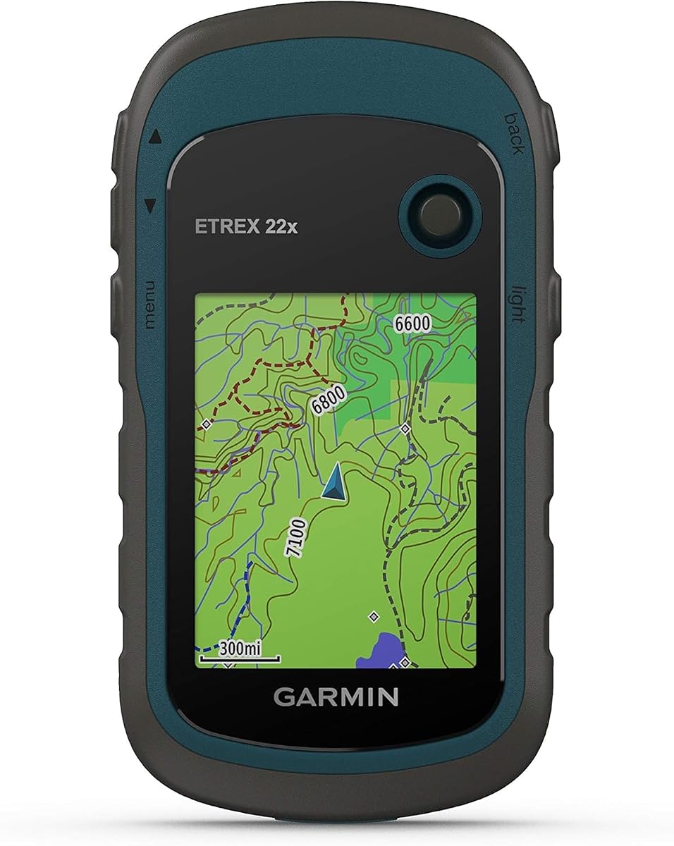
The Garmin eTrex 22x is a compact handheld GPS navigator that serves well for general boating and shoreline exploration. It holds a 4.3 rating from users who appreciate its simplicity and long battery life.
We may earn a commission when you buy through this link, at no additional cost to you.
Its standout qualities include a 2.2-inch sunlight-readable display and preloaded Topo Active maps with routable roads and trails. While better for land navigation, it provides reliable positioning for coastal cruising and fishing spots.
The device supports GPS and GLONASS satellite systems for tracking in challenging environments. It also offers 8 GB internal memory plus a micro SD card slot for additional map downloads and route storage.
Boaters who need a lightweight and budget-friendly handheld GPS for boating should consider this model. It is excellent for short trips where detailed coastal charts are less critical than general positioning.
With up to 25 hours of battery life on two AA batteries, this unit supports long days on the water. The replaceable batteries ensure you never face a dead device mid-trip.
The micro SD card slot allows you to add extra maps or save extensive waypoints and tracks. This flexibility is useful for frequent explorers who want to customize their navigation data.
We may earn a commission when you buy through this link, at no additional cost to you.
The Garmin GPSMAP 86Sci is a premium handheld GPS that combines marine navigation with satellite communication capabilities. It holds a 4.2 rating from users who value safety features like SOS and two-way messaging.
We may earn a commission when you buy through this link, at no additional cost to you.
Its standout qualities include InReach satellite communication for staying connected even out of cellular range. The preloaded BlueChart g3 coastal charts ensure accurate navigation while the floating design adds practical safety for boating.
The device functions as a remote control for compatible Garmin autopilot and Fusion products. It also offers adjustable GPS filters to smooth speed and heading indications over swells for better readability on rough water.
Boaters who prioritize safety and connectivity should choose this handheld GPS for boating. It offers advanced features like location sharing and weather forecasts that go beyond standard navigation tools.
With an active satellite subscription, you can trigger an interactive SOS to a 24/7 search and rescue monitoring center. You can also share your location with others via GPS-based tracking for peace of mind.
Stream boat data from compatible chartplotters and instruments to consolidate your marine system information. The device can also control autopilot systems through downloadable apps from the Connect IQ store.
We may earn a commission when you buy through this link, at no additional cost to you.
The Garmin GPS 73 is a specialized handheld GPS designed with sailing features for racing and cruising. It holds a 4.4 rating from users who appreciate its intuitive interface and dedicated sailing tools.
We may earn a commission when you buy through this link, at no additional cost to you.
Its standout qualities include SailAssist features like a virtual starting line and tack assist. The device also provides marine alarms such as Man Overboard and anchor drag alerts to keep you safe on the water.
The device uses two AA batteries to provide over 18 hours of operation. It stores up to 1,000 waypoints and 100 tracks, which helps you return to favorite fishing spots or anchorage areas easily.
Sailors looking for a straightforward and feature-rich handheld GPS for boating should consider this model. It focuses on core sailing navigation needs without unnecessary complexity.
Features like virtual starting line, countdown timers, speed history, and tack assist are tailored for racers and serious sailors. These tools help optimize performance during regattas or coastal sailing trips.
With dedicated backlit buttons and an intuitive user interface, operation is quick even with gloved hands. The device focuses on essential marine features like MOB and route planning.
We may earn a commission when you buy through this link, at no additional cost to you.
The Garmin GPSMAP 79sc Renewed offers the same powerful features as the new model at a more accessible price point. It holds a 4.8 rating from users who value certified refurbished quality and performance.
We may earn a commission when you buy through this link, at no additional cost to you.
Its standout qualities include a floating design that prevents loss overboard and a high-resolution display visible in bright sunlight. The preloaded BlueChart g3 coastal charts provide essential navigation data right out of the box.
The device supports multiple satellite constellations like GPS, GLONASS, and Galileo for reliable tracking worldwide. It also tracks up to 10,000 waypoints and 250 routes for complex journey planning.
Boaters looking for a budget-friendly option should consider this handheld GPS for boating. It provides premium features without the full retail cost, ideal for those new to marine navigation.
Renewed products undergo inspection and testing to ensure they meet quality standards. You get the same rugged durability and coastal chart coverage for a fraction of the new device price.
With IPX6 water resistance and a floating design, this device is built to withstand splashes and accidental drops. The tilt-compensated compass provides accurate heading even when the boat is stationary.
We may earn a commission when you buy through this link, at no additional cost to you.
The Garmin GPSMAP 65 is a button-operated handheld GPS that offers multi-band technology for optimal accuracy. It holds a 4.5 rating from users who need precision in challenging locations like urban canyons.
We may earn a commission when you buy through this link, at no additional cost to you.
Its standout qualities include a large 2.6-inch sunlight-readable color display. It also supports expanded global navigation satellite systems and multi-band tech to ensure tracking where GPS alone might struggle.
The device includes routable TopoActive mapping and a federal public land map. It works with the Garmin Explore website and app to help manage tracks, routes, and waypoints from the field.
Boaters who frequently venture between water and land should consider this handheld GPS for boating. It bridges the gap between marine and outdoor navigation with versatile mapping features.
Expanded global navigation satellite systems and multi-band technology allow you to get optimal accuracy in challenging locations. This ensures reliable positioning even in areas with dense trees or steep terrain.
The Garmin Explore website and app help you manage tracks, routes, and waypoints easily. This connectivity allows seamless planning and review of your trips from your smartphone.
We may earn a commission when you buy through this link, at no additional cost to you.
The Garmin eTrex 32x is a rugged handheld GPS navigator that adds a 3-axis compass and barometric altimeter. It holds a 4.2 rating from users who appreciate its detailed sensor suite.
We may earn a commission when you buy through this link, at no additional cost to you.
Its standout qualities include a 2.2-inch sunlight-readable display and preloaded Topo Active maps. While better for land navigation, it provides reliable positioning for coastal cruising and hiking alongside boating trips.
The device supports GPS and GLONASS satellite systems for tracking in challenging environments. It also offers 8 GB internal memory plus a micro SD card slot for additional map downloads and route storage.
Boaters who explore both water and terrain should consider this handheld GPS for boating. It offers robust features for varied environments without sacrificing core navigation accuracy.
Adding a 3-axis compass and barometric altimeter allows precise heading and elevation tracking. This is especially useful when navigating hilly shorelines or tracking weather changes via pressure.
Built for outdoor exploration, the device withstands rugged conditions. The sunlight-readable display ensures you can check your position even in bright midday sun on the water.
We may earn a commission when you buy through this link, at no additional cost to you.
The Garmin eTrex SE is a GPS handheld navigator designed for simplicity and extended use. It holds a 4.2 rating from users who value long battery life and basic functionality.
We may earn a commission when you buy through this link, at no additional cost to you.
Its standout qualities include a 2.2-inch high-resolution display readable even in bright sunlight. The water-resistant design is rated to IPX7, making it suitable for boating conditions with exposure to water.
It offers a battery life of up to 168 hours in standard mode. Pairing with the Garmin Explore app allows wireless software updates and additional mapping features to enhance its utility.
New boaters looking for a cost-effective handheld GPS for boating should consider this model. It provides essential navigation without a high price tag, ideal for casual weekend outings.
With up to 168 hours in standard mode and 1,800 hours in expedition mode, this unit lasts days on one charge. The replaceable AA batteries ensure you can swap power sources easily.
Pair with the Garmin Explore app on your compatible smartphone for wireless updates and notifications. This connectivity enhances the device without adding complex hardware to your setup.
We may earn a commission when you buy through this link, at no additional cost to you.
The Garmin GPS 76 is a handheld GPS navigator that offers WAAS enabled reception for better accuracy. It holds a 4.6 rating from users who appreciate its simplicity and reliability for basic tasks.
We may earn a commission when you buy through this link, at no additional cost to you.
Its standout qualities include continuous tracking of up to 12 satellites and a built-in trip computer. The trip computer shows current and average speed, timer, and trip distance to help you track your journey.
The device provides up to 16 hours of use from two AA alkaline batteries. While older, it remains a functional tool for simple positioning without needing advanced map overlays.
Boaters needing a straightforward and affordable handheld GPS for boating might consider this model. It provides core navigation features without complex menus or connectivity requirements.
WAAS enabled Global positioning system receiver continuously tracks and uses up to 12 satellites for better accuracy. This ensures reliable positioning even without advanced marine chart support.
The trip computer tracks current and average speed, timer, and trip distance. This helps you monitor your time on the water without needing separate tools or apps.
We may earn a commission when you buy through this link, at no additional cost to you.
Choosing the right handheld GPS for boating involves balancing features, durability, and map data. Here are the key factors to consider before making your purchase.
Marine GPS units come with varying levels of map data. Some include preloaded coastal charts with depth contours and hazard markers while others offer only basemaps. Look for units with BlueChart g3 or similar marine-specific data if you navigate coastal waters often.
Prioritize models that offer detailed chart coverage for your typical routes. Preloaded maps save time and money while ensuring you have accurate navigation data ready to use.
The marine environment is wet and unpredictable. Ensure your GPS has an IPX6 or higher rating to withstand splashes. A floating design is a critical safety feature that prevents the device from sinking if dropped overboard.
Always choose a unit designed to float if you are on open water. This simple feature can save you significant cost and ensure you never lose navigation capabilities mid-trip.
Modern GPS units support multiple satellite constellations like GPS, GLONASS, Galileo, and Beidou. This multi-GNSS support improves accuracy and signal reliability especially in challenging areas like urban canyons or near cliffs.
Select a model with expanded satellite support for better tracking worldwide. It ensures you maintain a strong signal even when one network experiences interference.
Marine excursions can last for days so battery life is crucial. Look for units offering 20 or more hours of GPS mode. Devices using replaceable AA batteries are often better for extended trips than fixed lithium options.
Prioritize battery life that matches your longest planned trip. AA batteries are easy to swap and widely available if you go out for multiple days.
Bright sunlight is common on the water so a high-resolution sunlight-readable display is essential. Larger screens make it easier to view charts and data without squinting. A scratch-resistant and fogproof glass adds durability.
Choose a display size that balances visibility with portability. A 2.6-inch screen often offers enough space for reading maps without making the device too bulky.
A built-in 3-axis tilt-compensated compass provides heading even when the boat is stationary. Barometric altimeters track pressure changes to help pinpoint altitude which is useful near coastal cliffs or bridges.
These sensors add valuable context to your navigation data. They ensure you know your direction and elevation regardless of movement or speed.
Some models offer satellite communication like InReach for two-way messaging or SOS. This connectivity keeps you safe when out of cellular range. Other features include remote control for autopilots or data streaming from instruments.
Consider units with safety communication features for remote sailing. Staying connected can be life-saving during emergencies far from shore.
You will need to save many waypoints for favorite spots routes and hazards. Look for units with at least 10,000 waypoints and 250 routes. Internal memory and SD card slots allow for map expansions and data storage.
Prioritize ample storage if you are an avid explorer. It ensures you can track complex journeys and revisit locations easily without data limits.
Always calibrate your compass before heading out on open water. Use the built-in calibration routine if available and keep the unit away from metal objects that interfere with magnetic sensors.
Keep the device away from direct sunlight when not in use to prevent screen overheating. Store it in a dry place and wipe off saltwater or moisture after every trip to maintain water resistance.
Update the software and maps regularly through the manufacturer website or app. Fresh data ensures accurate navigation and adds new features or improvements released by the manufacturer.
Most handheld GPS devices function without a subscription for basic positioning and preloaded maps. However, satellite communication features like messaging or SOS require a subscription. Check the product details to see what services need ongoing fees.
Most are water resistant with ratings like IPX6 or IPX7 meaning they can handle splashes or immersion for short periods. They are not fully waterproof for prolonged deep submersion so avoid dropping them in deep water.
While handheld GPS provide positioning they are not replacements for dedicated marine chartplotters. They are ideal as backups or for small boats. Always have a dedicated chartplotter for large vessels or complex navigation.
Battery life ranges from 16 to 25 hours on GPS mode for most units. Some models offer extended expedition modes that last over 100 hours. Consider your trip duration and whether replaceable batteries are needed.
Many units come with preloaded coastal charts or basemaps ready to use. Some may require downloading specific maps via software. Check product details to confirm if your target area has preloaded coverage.
Modern units support multiple satellites so signal loss is rare. If signal drops the compass and cached data help keep your heading. Reacquisition is usually quick once the view clears or obstacles move away.
Some premium models allow you to stream data from compatible chartplotters and instruments. This consolidates marine system info on your handheld. Check compatibility before purchase to ensure your boat systems work together.
Use a secure marine-grade bracket that keeps the device visible but stable. Ensure the mounting point is away from heavy spray areas yet easily accessible. Always attach a lanyard as an extra safety measure.
Choosing the right handheld GPS for boating ensures safety and confidence on the water. The Garmin GPSMAP 79sc leads with coastal charts and rugged features while the eTrex SE offers value for entry-level needs.
Prioritize features like floating design chart quality and battery life based on your typical routes. Whether you sail offshore or fish locally having reliable navigation helps you return safely every time.
Prices and availability change often so check current listings before finalizing your decision. A trusted handheld GPS is an investment in your safety and peace of mind on every boating adventure.